Nepal-Tibet Flood Threat: New Danger Emerges
A new flood threat is emerging along the Nepal-Tibet border after a catastrophic glacier collapse triggered deadly flash floods across the Himalayan region, with authorities now monitoring a debris-dammed lake that could send another surge downstream. Nepal’s latest reported figures put the death toll at 469, with 977 people missing, while Chinese authorities have reported additional deaths and missing people in Tibet. The situation remains fluid as rescue teams search devastated communities and authorities assess the risk posed by rising water behind the natural barrier.
The immediate danger is no longer confined to the destruction caused by Wednesday’s flood. Debris from the collapse has altered river channels and created a barrier lake near the affected border region. Nepali and Chinese authorities have warned that a sudden breach could produce another destructive flood along river systems already overwhelmed by the first disaster.
Nepal-Tibet Flood Threat Emerges After First Disaster
The new danger developed from the same chain of events that caused the original catastrophe.
On Wednesday morning, a massive section of glacier and rock collapsed in the Himalayan border region. The falling material generated enormous seismic energy, initially leading to reports of an earthquake. The United States Geological Survey subsequently determined that the seismic signal was associated with the collapse of glacial rock and ice rather than a conventional tectonic earthquake.
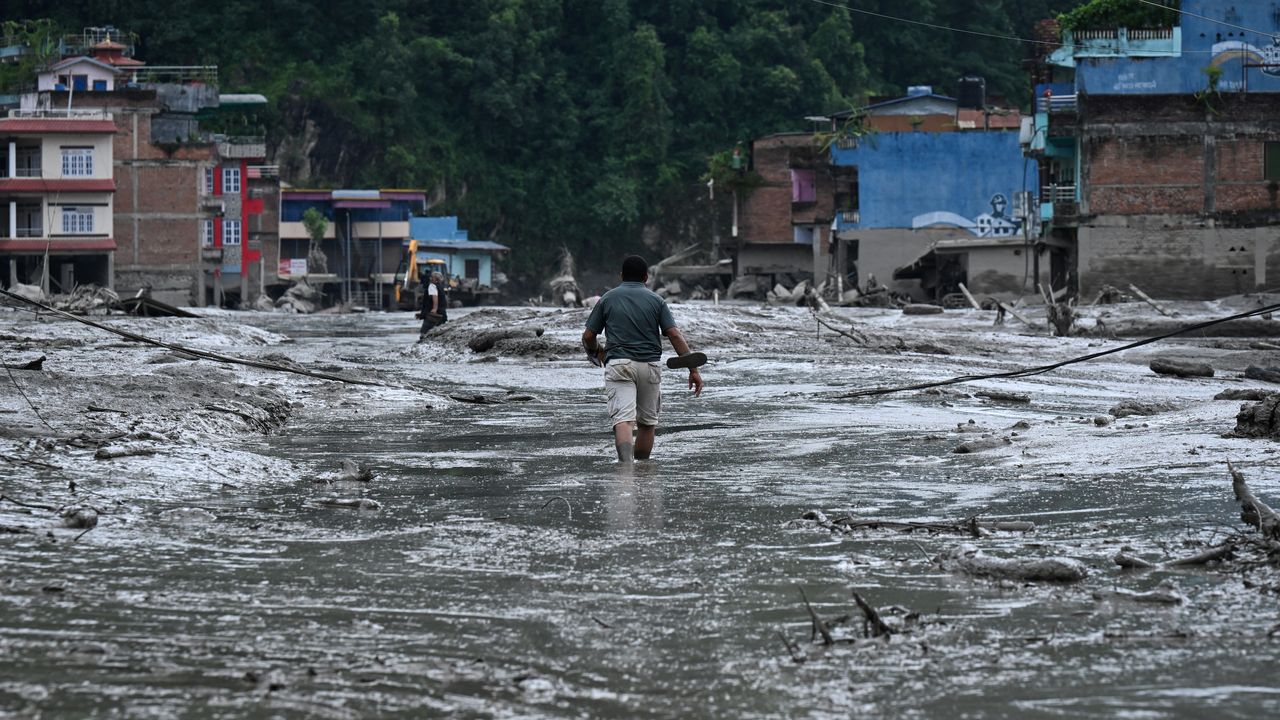
The collapse sent ice, rocks, mud and water into river systems below, producing a fast-moving debris flow that devastated settlements and infrastructure along the Lhende, Bhote Koshi and Trishuli river systems.
The scale of the destruction has continued to become clearer as rescuers reach previously inaccessible areas.
The latest casualty figures have changed substantially within hours as bodies have been recovered and missing-person lists updated. Al Jazeera reported on Friday that Nepal had confirmed 469 deaths and 977 missing people, while Chinese authorities reported three deaths and 558 missing in Tibet.
Reuters later reported a higher Nepal death toll, underscoring the rapidly changing nature of the emergency and the difficulty of establishing a final count while search operations continue.
How the New Barrier Lake Was Formed
The Nepal-Tibet flood threat is linked directly to the physical debris left behind by the first disaster.
When the glacier and surrounding terrain collapsed, enormous quantities of rock, mud and ice entered the river system. Some of that material accumulated across a river channel, effectively forming a natural dam.
Water then began accumulating behind the debris.
Al Jazeera reported that scientists identified two newly formed lakes associated with the disaster. One developed higher in the glacier area, while another, larger lake formed when landslide debris blocked the Lehende river system.
The lower lake is particularly concerning because of its location upstream of the Bhote Koshi and Trishuli rivers.
That means a sudden failure of the natural barrier could potentially send water and sediment through a corridor that has already suffered extensive destruction.
China’s Ministry of Water Resources estimated that the lake contained roughly 1.5 million to 2 million cubic metres of water and warned that approximately another 3 million cubic metres could flow into the area over three days.
The volume is significant because a natural dam made from loose rock, mud and debris does not provide the same stability as an engineered dam.
If water begins cutting through the debris barrier, erosion can accelerate rapidly.
The resulting flood would also carry large quantities of sediment and rocks, potentially making the downstream surge more destructive than ordinary floodwater.
Nepal-Tibet Flood Threat Complicates Rescue Operations
The new danger presents emergency authorities with a difficult operational problem.
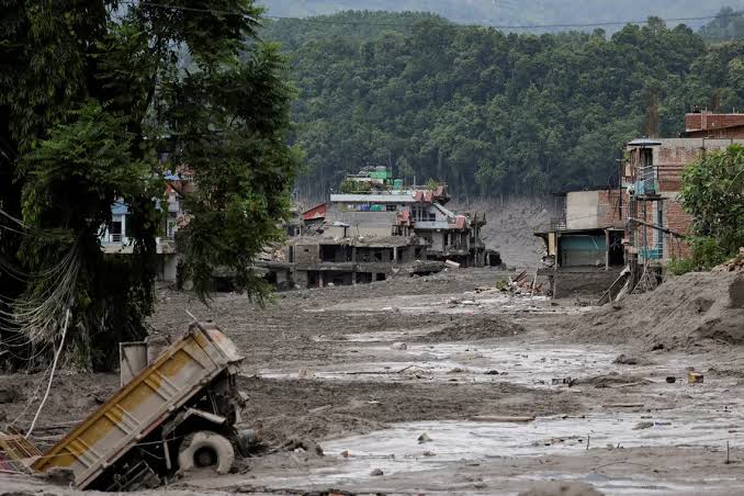
Rescue teams are still searching for people who disappeared during the first flood. At the same time, the possibility of another surge means rescuers cannot simply concentrate on the most heavily damaged areas without considering their own safety.
Operations were temporarily suspended after the barrier lake began affecting water levels, although Reuters reported that Chinese authorities later assessed the risk as manageable and allowed rescue operations to resume.
The disruption illustrates the unusual nature of the disaster.
In a conventional flood, rescuers generally work after the water begins to recede. In this case, however, the landscape itself has been transformed by the initial collapse.
River channels have shifted. Debris has accumulated across valleys. Roads and bridges have disappeared. And new bodies of water have emerged in locations where lakes did not previously exist.
That creates an environment in which the geography of the emergency can change even while rescue operations are under way.
Why the Second Flood Could Be More Dangerous
A second surge would not necessarily repeat the first flood in exactly the same way.
The newly accumulated water could erode the debris barrier and mobilise material deposited during the original collapse.
Scientists cited by Al Jazeera warned that a breach could carry mud and rocks downstream, further complicating search-and-rescue efforts and potentially threatening hydropower tunnels and infrastructure.
This is particularly important because the first disaster has already weakened access routes and damaged infrastructure.
The same river corridors that could carry another flood are also important transport and communication routes for rescue teams.
A further surge could therefore have a double impact: directly threatening people downstream while simultaneously cutting off the people trying to help them.
Nepal’s disaster authorities have consequently warned people downstream, travellers and rescue personnel to stay away from vulnerable riverbanks.
A Disaster Spreading Beyond the Original Flood Zone
The Nepal-Tibet flood threat is not limited to the immediate location where the glacier collapsed.
The affected rivers form a connected system through which water and sediment can travel considerable distances.
The Bhote Koshi eventually connects with the Trishuli system, creating a potential pathway for any sudden release to move toward downstream communities.
That geographical connection is one reason authorities are watching water levels beyond the original disaster site.
The risk also extends to infrastructure.
The first flood destroyed or damaged roads, bridges, buildings and power facilities. Satellite imagery and aerial assessments have shown extensive changes to river channels and heavy sediment deposition across affected valleys.
For communities that depend on those transport corridors, the damage is likely to complicate recovery long after the immediate rescue operation ends.
Tourists and Pilgrims Among the Missing
The disaster has also acquired an international dimension because the affected region is a major route for trekkers, mountaineers and religious pilgrims.
The Nepal-Tibet border connects travel routes between Nepal and Tibet, including routes associated with Mount Kailash and Lake Mansarovar.
Earlier reports identified hundreds of foreign nationals among those missing, including tourists and pilgrims from several countries.
That international dimension has created a second emergency away from the disaster zone: families and governments attempting to establish the whereabouts of people who were travelling through a remote mountainous region when communications and transport links were destroyed.
The problem is compounded by the fact that the casualty and missing-person figures are changing rapidly.
Authorities have warned that lists may contain people whose status remains uncertain, making it difficult to establish exactly how many people are still unaccounted for.
The Scientific Warning Behind the Disaster
The immediate trigger was a glacier and rock collapse, but scientists have also highlighted the broader environmental vulnerability of the Himalayas.
The Hindu Kush Himalayan region contains some of the world’s most important glaciers and provides water to hundreds of millions of people downstream.
The combination of steep mountain slopes, unstable terrain, glaciers and rapidly changing climatic conditions creates the potential for cascading hazards.
The Associated Press reported that satellite imagery showed a massive collapse of bedrock beneath a glacier on Langtang Lirung peak, sending ice, boulders and debris into the valley. Experts said warming temperatures can degrade permafrost and destabilise high-altitude slopes, although they cautioned that a direct climate-change link to this particular collapse cannot yet be conclusively established.
That distinction matters.
It is reasonable to examine the disaster in the context of a warming Himalayas, but the precise contribution of climate change to an individual glacier collapse requires scientific investigation.
The broader trend, however, is increasingly concerning.
Researchers have documented rapid changes in Himalayan glaciers and an increased concern about glacial lake outburst floods and other high-altitude hazards.
The Himalayas Have Seen Similar Cascading Hazards
The current disaster is extraordinary in scale, but glacier-related collapses and glacial lake outburst floods are not new to the Himalayan region.
Al Jazeera’s review of previous incidents points to major glacier collapses in Tibet in 2016 and 2022, as well as glacial lake outburst flooding in northern Pakistan.
These events demonstrate why scientists and disaster authorities are increasingly concerned about cascading hazards.
A glacier does not have to produce a conventional flood by itself.
A collapse can trigger an avalanche. The avalanche can enter a river. The river can become blocked. The blockage can create a lake. The lake can then breach and produce another flood.
In other words, one high-altitude event can create several successive hazards.
That is precisely what makes the present Nepal-Tibet flood threat particularly difficult to manage.
What the Disaster Means for Infrastructure
The immediate humanitarian crisis is likely to be followed by a substantial reconstruction challenge.
Roads and bridges are essential to communities in mountainous regions because alternative routes are limited.
When a bridge disappears, a community may effectively become isolated.
When a road is buried under sediment or destroyed by a river, moving food, medicine and rescue equipment becomes substantially more difficult.
Hydropower infrastructure also faces risks.
The affected river systems contain major hydropower projects and associated tunnels. Any renewed surge could threaten facilities that survived the first flood while also disrupting electricity generation and reconstruction efforts.
The economic impact could therefore extend beyond the directly flooded settlements.
Tourism is another vulnerable sector.
The region attracts trekkers, pilgrims and mountaineers, and the destruction of accommodation, roads, border facilities and transport routes could disrupt travel for an extended period.
A Cross-Border Disaster Requiring Cross-Border Monitoring
The geography of the emergency also makes cooperation between Nepal and China unavoidable.
The rivers, glaciers and mountain slopes do not follow political boundaries.
A landslide or glacier collapse on one side can affect communities on the other.
The current crisis has already required information-sharing between the two countries, particularly concerning the developing barrier lake.
Chinese authorities have deployed engineering teams and technical equipment to assess the lake and model potential flood consequences.
Such cooperation is likely to become increasingly important as satellite monitoring and early-warning systems improve.
For mountainous countries, disaster preparedness increasingly involves monitoring conditions far upstream from the communities that are ultimately at risk.
What Happens Next
The immediate priority remains the search for survivors and missing people.
But authorities now have to manage several objectives simultaneously: continue rescue operations, protect emergency workers, monitor the barrier lake, warn downstream populations and prevent further loss of life.
The latest assessment that the immediate lake risk is manageable has allowed rescue operations to resume, but it does not mean the wider danger has disappeared.
Water levels, rainfall and the stability of the debris barrier will remain critical factors.
The situation could therefore change quickly.
For communities already devastated by the first flood, another major surge would be particularly dangerous because many people have lost homes, transport routes and access to essential services.
The Nepal-Tibet Flood Threat Is Now a Race Against Time
The defining feature of the disaster is no longer simply the scale of the original flood.
It is the possibility that the landscape created by the first event could generate another emergency.
The glacier collapse produced the first wave of destruction. The debris left behind has created new hazards. And the water accumulating behind those natural barriers represents a potential second stage of the crisis.
That makes monitoring as important as rescue.
The final death toll will continue to change as teams reach isolated areas and recover bodies. The number of missing people will also be revised as survivors are located and families receive information.
But one fact is already clear: the Nepal-Tibet disaster has become more than a single flood event.
It is an example of how a high-altitude geological collapse can trigger a chain of interconnected humanitarian, environmental and infrastructure crises.
For the people still living downstream, the priority now is simple: ensure that the disaster that began with a collapsing glacier does not produce another devastating flood.
This is a developing story. DSG Herald News will update this report as verified information becomes available.
Recommended Coverage
Rivers Church Flood Exposes Drainage Crisis
Flood disasters aren’t only about the amount of rain or water—infrastructure can determine how severe the damage becomes.
Explore to see how drainage failures can turn flooding into a serious public-safety crisis.
Jigawa Boat Accident Leaves Eight Dead
The Nepal disaster also highlights how quickly water-related emergencies can become deadly when communities are caught in dangerous conditions.
Read this report for another sobering look at the human cost of water-related disasters in Nigeria.
Peru Earthquake: Why a 5.1 Tremor Turned Deadly
Natural disasters can become far more destructive when geography, infrastructure and preparedness collide.
Explore this analysis to understand why even a seemingly moderate natural event can produce deadly consequences.
About the Author